Wild Wollemi
 From Richmond, head west on the Bells Line of Road, over the Hawkesbury River. Turn into Comelroy Road at Kurrajong heading to the remote Wheeny Creek camping and picnic area – there are basic camping, barbecue and picnicking facilities here. Stop and explore this photographic area with its crystal clear waters. Listen for the native bird and frog calls.
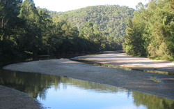
- Follow the windy roads along the wild ridges of the Wollemi National Park, stopping at the Upper Colo River camping and picnic areas. Swim or lilo on the stunning sandy Colo River. The Colo River is 86km long and cuts through the heart of the Wollemi National Park. The Colo River Wilderness is one of the last ‘pristine’ rivers and is where the Wollemi Pine was discovered in 1994. The Upper Colo Camping/Recreation Reserve is situated beside the Colo River and covers 13.8 hectares, two-thirds is native bushland. This reserve offers a wilderness camping experience (bookings are essential) but is open to day trippers too. Eastern grey kangaroos, wombats, red-necked wallabies and wallaroos are often seen in the early morning or late afternoon grazing on the grassy stream banks. Colo Wilderness has been identified as one of the 20 real wilderness areas remaining in South East Australia.
- Heading back towards the Putty Road, drop into the Colo Riverside Café if you need a snack or supplies. Besides being a café it is a liquor and general store.
- Drive to Colo Heights along the Putty Road and take a bushwalk along the Bob Turners Track to a remote river beach deep in the wilderness. Access to the walk is marked with a NPWS sign – ‘Bob Turners Track – Wollemi National Park’. There is a car parking area at the end of the dirt track. From here it's a 4 hour return walk and make sure you are prepared and take plenty of drinking water. The track is well marked but steep in places.
- The Putty Road is the main road north and was constructed during the 1820s, following a meandering route to negotiate remote valleys, sheer-sided gorges and wild rivers. It is a picturesque alternative route from the Hawkesbury to Singleton and Cessnock in the Hunter Valley.
35km/50 minutes one way without stops